Adventure #2: Avoncliff to Farleigh Hungerford
by John Walker on Jun.07, 2006, under The Rest
As I mentioned, when living in Winsley I wasted a lot of opportunities. Winsley’s an odd place. It’s about a mile square, and now that I’ve left it has no residents between the age of 18 and 40. It’s the sort of place parents think would be a good place to raise children, but children go out of their mind with crazed boredom – beautiful hills and open fields, rivers running through gardens, and even the modern estate a friendly and quiet area. (It has a secret poor area hidden behind some walls but no one talks about that). With one shop and half a pub, it really should be lived in by only retirees, and it wouldn’t take much for that to be the case. But there are worse places to live, and having worked for three years with the teenagers who live there, I’m aware it produces good people.
I think my failure to explore it properly boils down to being very lonely while I lived there. Increasing my sense of isolation by standing in the middle of an empty field wasn’t all that enticing when I was already going stir-crazy for company in the middle of the populated area. When friends came to stay it all changed, and I would excitedly drag them down tiny stone passageways to show the beautiful countryside, and occasionally make the downhill treck to the nearby Avoncliff to get food at the restaurant down there, and have them smell the World’s Most Disgusting Smelling River.
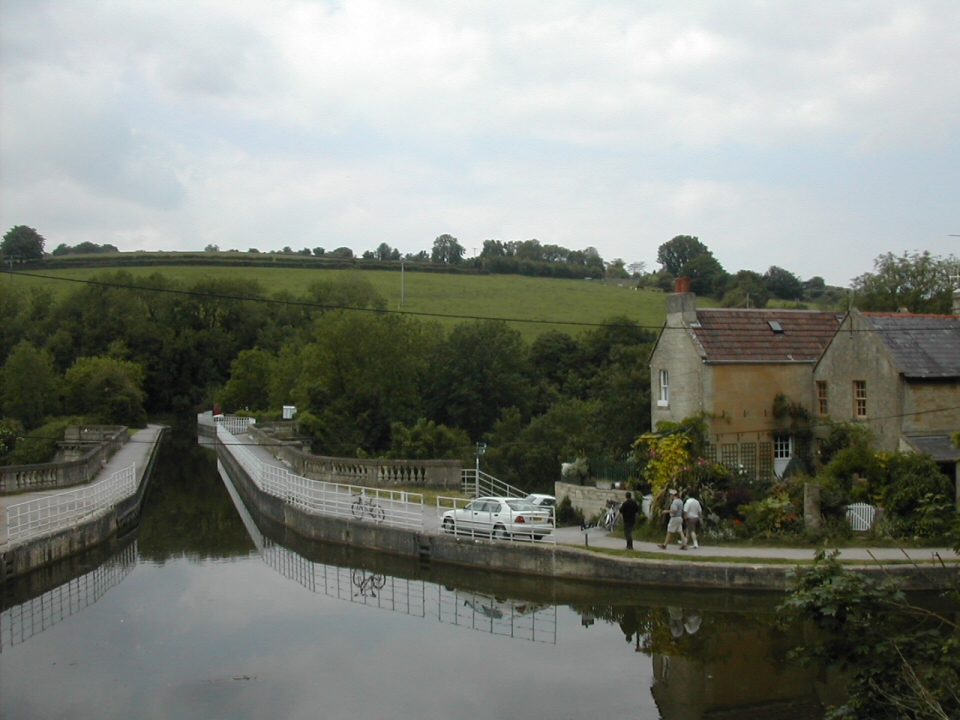
This is the canal. No the water’s not going up hill, just an odd-angled photo. Like I said, Escher.
Avoncliff, despite the wretched fumes mysteriously belching out of the water, is extremely pretty. It has a low river running alongside the railway, and then fantastically an aqueduct carrying the canal over the river and traintracks. This leads to the creation of an Escher-like bridge confusion where to get to the railway platform from the other side of the canal and river involves going down and under the canal, up the other side, then across the bridge, and then back down again.
And so it was yesterday I decided I wanted to visit a castle. Looking at those nearby I saw that Farleigh Hungerford Castle was only 2 miles walk from Avoncliff, and the train stops at Avoncliff if you ask nicely. Seriously. When you get on you have to ask the conductor to stop the train there, and he lets you out his narrow door at the front, onto what I heard someone else say was the smallest train platform in England. To catch a train from there, as I later would, you must hold out your arm and flag it down. A very strange feeling. People should have been waving me off with hankies.
It was no easy journey. Fifteen minutes from my flat I realised I’d not brought my wallet, and so had to go all the way back. Weaker men would have been defeated by a half hour’s setback, but not me. I continued on to Waterstones to buy an OS map of the area. While the castle was meant to be only two miles from the station, nowhere said which two miles, and all internet maps ran out of detail once you zoomed that far in to that remote a place, and as has been recently established, with no sense of direction there’d be little hope for me to simply guess. Well, as it turns out, Farleigh Hungerford exists on the meeting point of three different OS grids, and manages the impressive feat of apparently featuring in none of them. I was going in blind. Feel the foreboding air.
An abortive attempt at buying a new camera filled in the time before getting to Bath Spa train station, so once more the accompanying pictures are taken on my increasingly senile old box, which is not only reluctant to give up its contents to the computer, but also seems to enjoy a spot of splattering splodges of colour into darker areas, and then going incredibly super-bright for no reason. A new one has been bought from Mr Internet, and this post is tributed to the life of my seven year old camera. May you smash to bits satisfyingly.
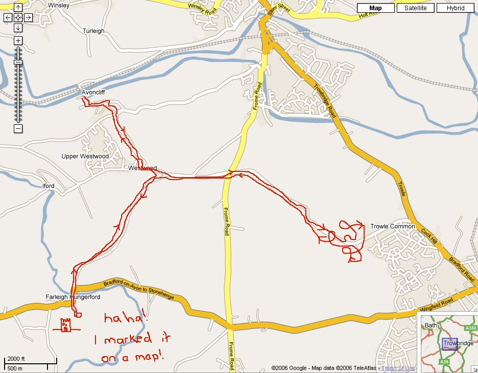
Let out onto Avoncliff’s teeny platform I made straight for the restaurant/pub to ask for directions. Inevitably the locals would have four or five parties a day popping in for FH Castle directions, so they’d roll their eyes and once more spell out the route. “I’m sorry, I’m from Yorkshire,” said the middle aged barman, in a tone that seemed to imply he believed he was currently in Yorkshire, and it was quite mad of me to have asked for directions for somewhere as far away as the South West of England. I spied a map of the local area on the bar and unfolded it.
Well there we go then. I feel like I’m already there, so vivid is the marked route!
That’s right – Farleigh Hungerford Castle is, it appears, illegal to mark on a map. Don’t believe me – follow the link to “View Map” on the Castle Explorer site.
A man sat at the bar – nay, at one with the bar – said he could give me directions. Then he sucked long and hard at his teeth, looking up as if picturing an outside world he’d not seen in years, and held an arm out confidently. And then swang it around by 180 degrees. Eventually settling somewhere between the two he entirely failed to give me directions for how to get out of the pub garden (I wish I were kidding), and boldy sent me off with instructions that would have had me walk straight into the river and then back to Bath.
Taking matters into my own hands I chanced upon a mounted sign ten yards away from the pub. I forgot to photograph it, so you’ll have to believe me when I tell you it featured the slightest hint of anything south, but did, once more, assure me that the castle existed. Just not how to get there. But from my fifteen seconds of research before I left, I remembered my hastily scrawled note telling me to try to go through Westwood, and Westwood featured. Not, I should add, anywhere near where the map above pretends it is. The sign gave one stern warning about all who chose to head to Westwood: “Steep hill” it declared in black text in the remote blank green at the bottom, much as a fearful explorer might have marked his map “Here Be Dragons”, before hurriedly sailing home.
A steep hill held no fear for me. I’d gone 200 yards behind my house not 12 hours ago! (It was not 12 hours ago. It was 18). I impressively clomped my way up what was indeed a steep hill, but it was a very sunny day, the trees were very green and the sky very blue, and it was a pleasure. And then as quick as you like (unless you like something unreasonably quick) I was in Westwood. (Appropriately only surly white people with too much money live in Westwood, but fortunately none of them seem to think themselves gangsta rappers). From here I must need only find a signpost and head down the next hill, and I would surely be in Farleigh Hungerford. There are no signs in Westwood.
That’s not quite true – there is a sign back to Avoncliff. But that’s the only one. And there were no people to ask. So given two choices I chose the one that felt the most like carrying on in the same direction and set off once more.
So remember that bit before about not having a sense of direction? After about half an hour I began to think something had gone wrong. I had walked for a long way down a long road with no signs at all. It was very pretty, and there was some manner of town in the distance, but it didn’t look the sort to contain a castle, and my feet were beginning to hurt in my rubbish shoes. It’s horrible to turn back and walk the way you came, but it was that or go all the way around the entire world on this endless road, so back I went.
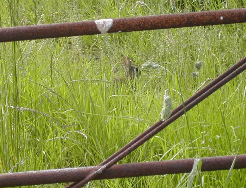
Fortunately bunny rabbits kept me company on my march of failure.
Reaching Westwood almost an hour after my last visit I found it to now be a bit more populated, with a whole one person walking her dogs. She told me to head in the very opposite direction to that which my amazing instincts had chosen, and to keep going until I reached a road, cross it and go past a church, and then it was just past there. Hurrah! Off I went, feet a bit sore, but with a goal. It was getting a bit mid in the afternoon, but it was just down the road and past the church.

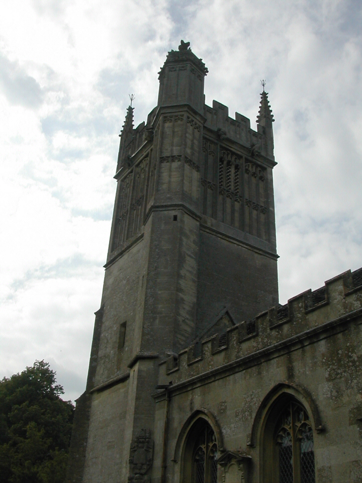
The lady really wasn’t kidding about the path taking me to a church. It deposited me neatly at its front entrance. It was a tiny and beautiful building, reasonably plain and then suddenly enormously elaborate at the top of its tower. I poked my head inside, and an eight hundred year old man sat in the entrance looked up and said hello. He invited me in to have a look around, and I had a quick peek. It was archaic, but clearly still in use, probably for a congregation as old as its bricks. The walls were covered in plaques and signs and wooden shapes with dedications to parishoners who had died, suggesting that a lot of people had been very loved in there. I obligingly dropped a coin into a box appearing to be collecting money for recovering the cushions, or some equally vital evangelistic exercise, and then the extremely kindly octo-centurian told me the next stage of my journey. I was to go through the graveyard, turn right, and follow the road. It would soon take me to the castle.
Now my legs were aching a bit. They hadn’t done much more than half an hour’s walk for a bit too long. And now they were getting close to another half hour’s along this road. I was sure the friendly church warden had told me it wasn’t very far. The road widened to acommodate a few houses and I stopped to ask a lady who was piling children into her car. She told me that I now needed to go down this road, go down the hill, and then up the other side, and it was on the right. It was as if each person were posted at positions along the route to give their specific share of the directions. None must know the whole route – they might mark it on a map!
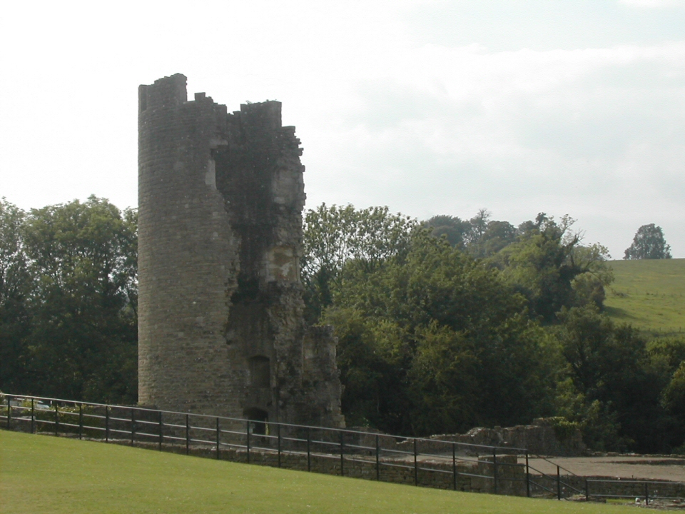
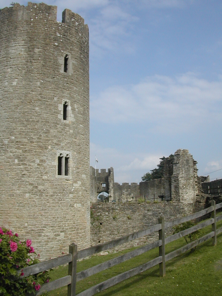
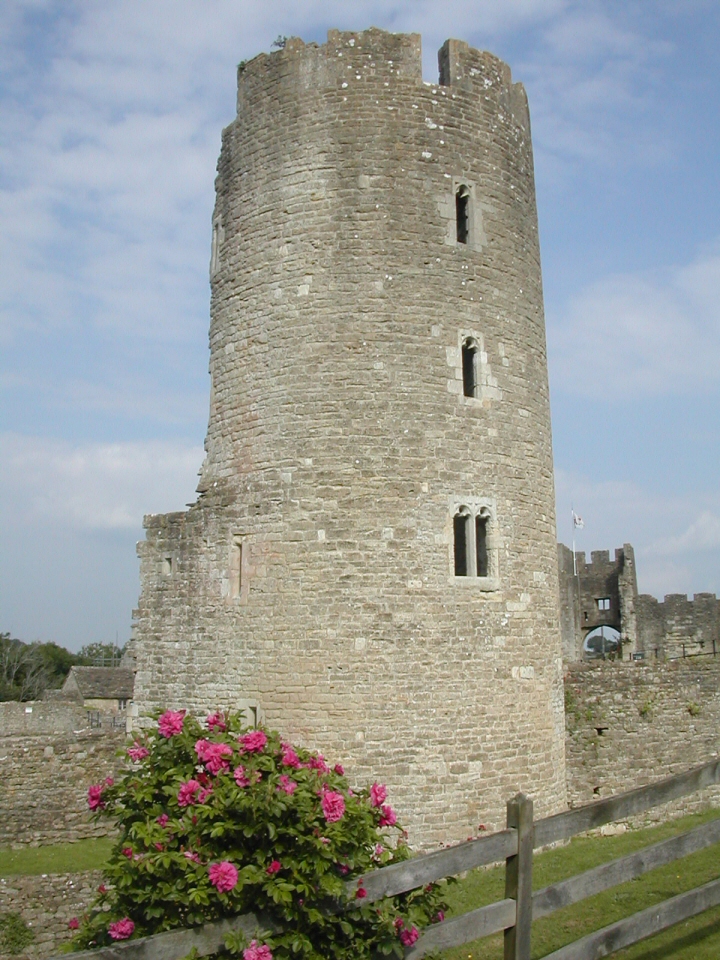
By this point my feet were throbbing, feeling swollen in my crappy walking shoes, and there was a fair ache setting into my legs. To be expected for being as lazy as me, but I couldn’t help remember that I’d be reversing this route (bar the detour) in a short while. And it was uphill on the way back. I was never more aware of this than when descending the crazy-steep slope before groaning up the other side. I could see the castle! I had made it!
Fifteen minutes before it closed.

So there was time for an ice cream, but certainly not time to spend £3.50 on a ticket to have a proper explore. But I did not let my seeming failure bring me down. I was there – I had made it, against the wishes of the evil cartel of cartographers, against the desires of extremely lost Yorkshiremen, and against the evil scheming plans of Britain’s useless signpost manufacturors. A return visit must be had (preferably by helicopter) to explore the crypt containing “portrait coffins”, and to go inside the crumbling towers.
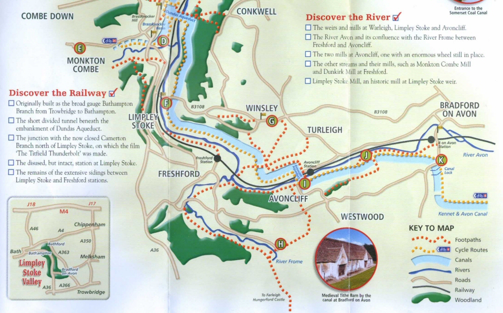
Just in case you think I’m exaggerating about this map business, here is the map included on the castle’s own pamphlet:
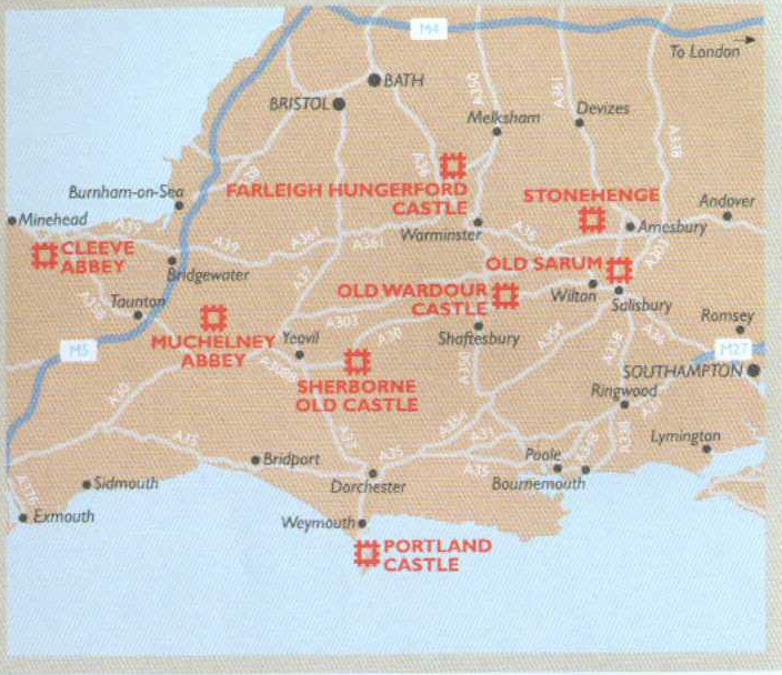
Not only is the castle marked as bigger than a city, but the it’s got BATH ABOVE BRISTOL! What in the name of unholy cartography is going on?!
So I’d love to tell you all about it, but I’d only be repeating what’s on the website, as I’ve absolutely no idea. I subtly hinted to the main at the ticket counter that with only 15 minutes to go, charging me for a micro-peek beyond the main pathway wouldn’t be entirely necessary. He told me what time they open in the morning, the horrid tight-arse ponytailed meanface.
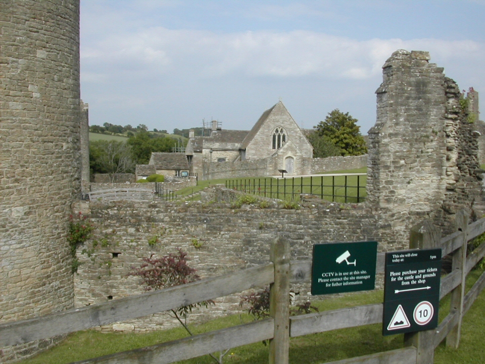
So I defiantly took photographs from the public right of way the carved its way through the very middle of the fort. That showed him.
Sat on a decaying bench outside the grounds I rested my weary legs for the whole five minutes I could spare, noticing that the hourly train left in one hour. It was hotfoot (literally) it back there and then, or have most of an hour to wait. Back I went. Without getting lost once. But OH MY GOODNESS it hurt. And hurt and hurt. My useless shoes have left my feet as only stubs, and my usless legs are still moaning and complaining about any movement. I’m such a colossal wimp.
But not colossal enough that I’m defeated. Oh no. This very night I’m off once more, to finally document Brown’s Folly – my favourite find in the whole area, and finally remember to take a camera with me.
June 7th, 2006 on 17:51
remind me when you’re here to take you down by the Chicago River. you will soon find that IT is the smelliest river. it’s so polluted that 100 some years ago they REVERSED THE FLOW OF THE RIVER to stop it from polluting Lake Michigan anymore (now it just pumps crap down to St. Louis…who cares!). http://en.wikipedia.org/wiki/Chicago_Sanitary_and_Ship_Canal
anyway, i enjoyed your tale. and pictures.
June 7th, 2006 on 19:13
“I was in Westwood. (Appropriately only surly white people with too much money live in Westwood, but fortunately none of them seem to think themselves gangsta rappers).”
WHAT??? I’m not surly!!
June 7th, 2006 on 21:17
Are you all the way out there?!
You’re definitely not surly. I’m clearly wrong. But do you think yourself a gansta rapper?
June 8th, 2006 on 14:59
Absolutely not. Princesses do not rap.
June 9th, 2006 on 14:03
I suppose They have people to do these things for them.